OpenWeather MCP, Ready to Go
Use OpenWeather MCP with Claude or Cursor to get real-time weather, air quality, and 16-day forecasts for any location globally.
No credit card required. Experience the power of this integration risk-free.
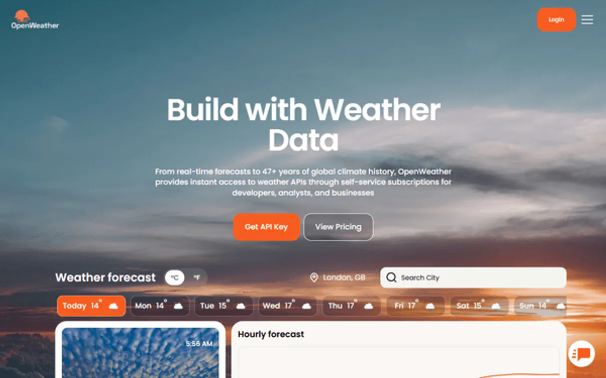
Get real-time weather data and 16-day forecasts for any global location.
Works with every AI agent you already use
…and any MCP-compatible client
How fast is the OpenWeather Connector?
Average time for the server to become ready for requests over the last 14 days, measured until the initialize / tools/list handshake completes. Metrics are updated daily between 00:00 and 04:00 UTC. Create a free account, use this Connector on Vinkius Cloud, and connect it to your AI agent in seconds.
Waiting for input…
What AI agents can do with OpenWeather MCP 11 Tools for Weather Data
Get live weather, air quality, and long-range forecasts for any location worldwide through your AI agent.
Geocode
Converts a city name into the top 5 matching locations with coordinates and country codes. Use this to get precise locations first.
Get air quality
Retrieves the current AQI and pollutant levels like PM2.5 and O3 for a specific location. It's useful for health monitoring.
Get air quality forecast
Provides a 4-day air quality forecast including AQI levels and specific pollutant concentrations. Plan ahead for air quality.
Get forecast
Gets a 5-day/3-hour weather forecast including temperature, humidity, and wind pressure. Good for short-term planning.
Get historical weather
Fetches temperature, humidity, and conditions for a specific past date in YYYY-MM-DD format. Use this for climate research.
Get current weather
Returns real-time temperature, humidity, wind, and visibility for a city or set of coordinates. Get instant updates.
Get daily forecast
Provides daily weather descriptions and min/max temperatures for up to 16 days. Perfect for long-term trip planning.
Get hourly forecast
Delivers an hourly forecast including precipitation probability and UV index for the next 48 hours. Use this for precise timing.
Get sun times
Returns the exact sunrise and sunset times along with the sun's elevation angle. Great for photography and solar planning.
Get weather alerts
Fetches active severe weather warnings, including severity and start/end times. Stay informed about dangerous conditions.
Reverse geocode
Converts a set of coordinates back into a city name, state, and country. Use this to identify locations from raw data.
A Connector is a URL. Vinkius runs it: hosting, security, governance, observability.
You're looking at one of 5,800+ managed Connectors. The real value isn't the catalog. It's the control plane that secures, governs, audits, and manages every interaction between your agents and the tools they use.
No Shadow AI
Every agent action is visible, approved, and auditable. Nothing runs outside your governance.
Absolute agent control
Fine-grained permissions for every agent, MCP, and tool. Instantly revoke access and audit every execution.
Cost control per token
Spend broken down to the token, tool, and agent. Budgets and hard limits. No surprise invoices.
Managed & monitored infra
We operate the runtime, authentication, scaling, retries, and monitoring. Your team manages AI, not infrastructure.
Data protection, DLP by design
Sensitive data is filtered before reaching the model. Access is governed so agents receive only the information they're allowed to use.
Token optimization, real savings
Lower AI costs by delivering the right context instead of unnecessary tools. Better accuracy, faster responses, and fewer wasted tokens.
OpenWeather MCP for Real-Time Meteorological Data
This is for people whose plans depend on the sky. It's for the travel coordinator who needs to know if a flight path is clear, the event organizer worried about rain, and the researcher tracking climate shifts.
Travel Coordinator
Checking multi-day forecasts and alerts to adjust itineraries on the fly.
Event Planner
Monitoring UV indices and precipitation probabilities for outdoor weddings or concerts.
Environmental Researcher
Pulling historical weather data and air quality trends for regional reports.
Outdoor Photographer
Getting exact sunrise and sunset times to plan lighting for shoots.
Frequently Asked Questions
Can I use OpenWeather MCP to check for severe weather alerts? +
Yes, the OpenWeather MCP pulls active severe weather warnings for any location. It provides the alert type, severity, and start/end times so you can stay informed about dangerous conditions.
Does the OpenWeather MCP provide air quality data? +
Yes, it provides both current air quality indices (AQI) and 4-day forecasts. You can see specific pollutant concentrations like PM2.5, PM10, and Ozone.
Can I get historical weather with OpenWeather MCP? +
Yes, you can fetch historical weather data for specific past dates. It returns temperature, humidity, wind, and general weather descriptions for your research.
Does OpenWeather MCP work for any city? +
Yes, it provides global coverage. You can search for weather in almost any city or use coordinates to get precise data for specific rural locations.
Can I get a 16-day forecast using OpenWeather MCP? +
Yes, it provides a daily forecast for up to 16 days. This is perfect for long-term planning when you need to see the general weather trend over several weeks.
How does OpenWeather MCP handle city names? +
It uses geocoding to automatically convert city names into the coordinates required for weather data. You don't need to know the latitude or longitude yourself.
How do I get an OpenWeather API key? +
Visit openweathermap.org/api, click Sign Up for a free account, go to API Keys in your account settings, and create a new key. Copy it — it's a 32-character hex string. Free tier includes 60 calls/minute.
Can I get weather alerts for my location? +
Yes! Use get_weather_alerts with lat/lon coordinates. Returns active alerts with sender name, event type, severity, description and start/end times. Useful for monitoring severe weather, floods, heat waves and other dangerous conditions.
Can I get historical weather data? +
Yes! Use get_historical_weather with lat/lon and a date in YYYY-MM-DD format. Returns the weather conditions for that specific day including temperature, humidity, wind and pressure.
How do I find coordinates for a city? +
Use geocode with the city name (e.g. 'London', 'São Paulo', 'Tokyo'). Returns the top 5 matching locations with their latitude, longitude, country code and state. Use these coordinates with other weather tools.
Your AI, connected to everything.


No credit card required · Free tier available


Other Connectors in this category
Withings Connector
Withings MCP lets you bring your health data directly into your AI agent. Track weight, blood pressure, sleep scores, steps, and workouts from your Withings scales and watches in one place. It's the fastest way to turn your biometric data into actual insights without jumping between different apps.
Tomorrow.io Connector
Tomorrow.io lets you pull hyperlocal weather intelligence into your AI agent. You can grab real-time conditions, 14-day forecasts, historical archives, and severe weather alerts from one place. It handles everything from current humidity and wind speeds to complex route weather for logistics planning. If you need precise meteorological data for apps, research, or operations, this Connector gets it done.
Tomorrow.io Connector
Tomorrow.io gives your agent hyper-local weather intelligence. It pulls real-time conditions, minute-by-minute forecasts, and air quality data from the Tomorrow.io platform. Use it to get precise environmental data for logistics, farming, or smart home automation without switching tabs.
Related Connectors
myClub Connector
Sports club management. Manage members, events, and invoices via myClub.fi.
Arrivy Connector
Manage field service tasks, crews, and customer bookings with Arrivy. Coordinate last-mile delivery and jobs via AI.
42Crunch Connector
Automate API security testing via 42Crunch. Manage collections, trigger audits, run conformance scans, and retrieve security reports directly from any AI agent.