Upstream Lens MCP for AI. Query Geospatial Data from Natural Language
 Gemini
 Works with every AI agent you already use
…and any MCP-compatible client
Connect to your AI in seconds.
Upstream Lens monitors environmental assets and conservation projects using satellite imagery and field data. It lets your AI client analyze geospatial metadata, track changes over time, and pull project notes directly from a natural conversation.
You can list all active projects, query available imagery layers (Sentinel, Landsat), and verify property details without leaving the chat window.
What your AI can do
Get property details
Fetches specific, detailed records for a known property feature ID.
Get organization info
Retrieves core metadata about your entire organization within Upstream Lens.
Check api health
Confirms if the Upstream Lens API is currently active and connected.
Lists every environmental project or portfolio managed under the Upstream Lens account.
Retrieves metadata about available satellite images (e.g., true color, NDVI) for a specific geographic area.
Pulls project notes and detailed observations to build an auditable timeline of changes at a site.
Retrieves the metadata for your connected Upstream Lens account or verifies API health.
Ask an AI about this
Waiting for input…
Upstream Lens MCP Server: 8 Tools for Environmental Data
Use these eight tools to run deep queries on environmental assets, retrieve metadata, track project history, and analyze geospatial data from your AI agent.
Make your AI actually useful.
Add this MCP to Claude, Cursor, or Windsurf and your AI stops guessing. It gets real tools to look things up, take action, and handle the stuff you keep doing by hand.
Start using Upstream Lens on VinkiusGet Property Details
Fetches specific, detailed records for a known property feature ID.
Get Organization Info
Retrieves core metadata about your entire organization within Upstream Lens.
Check Api Health
Confirms if the Upstream Lens API is currently active and connected.
List Property Imagery
Lists available satellite image layers (Sentinel, Landsat) for a specific property...
List Project Notes
Retrieves written field observations and notes, allowing filtering by update date...
List Project Observations
Lists detailed records of specific observations made during the course of a project.
List Portfolios
Lists all the high-level conservation portfolios you manage.
List Projects
Gathers a list of every active environmental project ID and name.
Security and governance baked right in.
Pick your AI client below to get set up. Just create a Vinkius account, subscribe, and you're instantly up and running. We handle the entire backend infrastructure, delivering out-of-the-box support for HTTPS Streamable, SSE, and OAuth2—zero messy routing required.
Claude AI
Open Claude Settings
Go to claude.ai, click your profile icon, then navigate to Customize → Connectors.
Add Custom Connector
Click the "+" button and select Add custom connector. Paste your Vinkius endpoint URL:
https://edge.vinkius.com/[YOUR_TOKEN_HERE]/mcp
Replace [YOUR_TOKEN_HERE] with your token
from cloud.vinkius.com. For OAuth-protected servers, expand
Advanced settings to add credentials.
Start a conversation
Open a new chat. The Upstream Lens integration is available immediately — no restart needed.
Choose How to Get Started
Build a custom MCP for your own tools, or connect a ready-made integration from our catalog.
Build Your Own
Turn any API into an MCP. Import a spec, define Agent Skills, or deploy with MCPFusion.
- Import from OpenAPI, Swagger, or YAML specs
- Create Agent Skills with progressive disclosure
- Deploy to edge with MCPFusion framework
- Built in DLP, auth, and compliance on every call
- Real time usage dashboard and cost metering
- Publish to catalog or keep private
Make Your AI Do More
Start with Upstream Lens, then connect any of our 5,100+ other servers whenever your AI needs more. One click, no limits.
- Use this MCP plus 5,100+ others, all in one place
- Add new capabilities to your AI anytime you want
- Every connection is secured and compliant automatically
- Track usage and costs across all your servers
- Works with Claude, ChatGPT, Cursor, and more
- New servers added to the catalog every week
Independent Platform Disclaimer: Vinkius is an independent platform and is not affiliated with, endorsed by, sponsored by, verified by, or otherwise authorized by Upstream Lens. All third-party trademarks, logos, and brand names are the property of their respective owners. Their use on this website is strictly for informational purposes to identify service compatibility and interoperability.
VINKIUS INFRASTRUCTURE
Cloud Hosted
Managed infra
V8 Isolated
Sandboxed per request
Zero-Trust Proxy
No stored credentials
DLP Enforced
Policy on every call
GDPR Compliant
EU data residency
Token Compression
~60% cost reduction
Works with Claude, ChatGPT, Cursor, and more
The Model Context Protocol standardizes how applications expose capabilities to LLMs. Instead of operating in isolation, your AI gains direct access to external platforms, live data, and real-world actions through secure, standardized connections.
This connection provides 8 powerful capabilities that interface natively with Claude, ChatGPT, Cursor, and other compatible AI platforms. No middleware. No custom integration required.
Sifting Through Environmental Reports takes Too Many Clicks Today.
Right now, tracking environmental data means jumping between a GIS portal for imagery, an internal database for property metadata, and a separate document management system for field notes. You spend half your day just copying IDs and pasting links into an email to assemble the full picture.
With this MCP server, you tell your agent exactly what you need—'Show me all assets in portfolio XYZ.' The agent handles the sequencing: it runs `list_projects`, grabs images with `list_property_imagery`, and pulls notes via `list_project_notes`. You get a single, synthesized answer.
Upstream Lens MCP Server: Get Structured Geospatial Data in Chat.
Before this, pulling data meant running manual reports and waiting hours for IT to stitch together the findings. If you needed a list of all assets, you'd run one report; if you needed imagery, you'd run another. Everything was siloed.
Now, asking 'What projects are active in the Midwest?' returns an immediate answer that combines project lists (`list_projects`), portfolio oversight (`list_portfolios`), and even confirms API connectivity status—all from the chat window.
What your AI can actually do with this
This server hooks your AI client up to Upstream Lens. You can run complex geospatial queries using plain language, pulling environmental data—like satellite images and field reports—and making it actionable right in the chat window.
Getting Started & Scope:
To make sure everything's running clean, you first need to check the connection status with check_api_health. For background info on your account, run get_organization_info; that pulls core metadata for your entire organization within Upstream Lens. You can scope out all the conservation work you manage by calling list_portfolios, which shows every high-level portfolio.
If you need to know what projects are active right now, list_projects gives you a list of every environmental project ID and name.
Property Deep Dive:
When you zero in on a specific piece of land, the server lets you pull down detailed records using get_property_details, which takes a known property feature ID to fetch all its specifics. For that same property, you can check what satellite images are available by calling list_property_imagery; this tool lists all layers—like Sentinel and Landsat—so you know if you're looking at true color or NDVI data.
If you just want the basics on a specific asset, you can also pull up comprehensive metadata about it using get_property_details.
Tracking Changes & History:
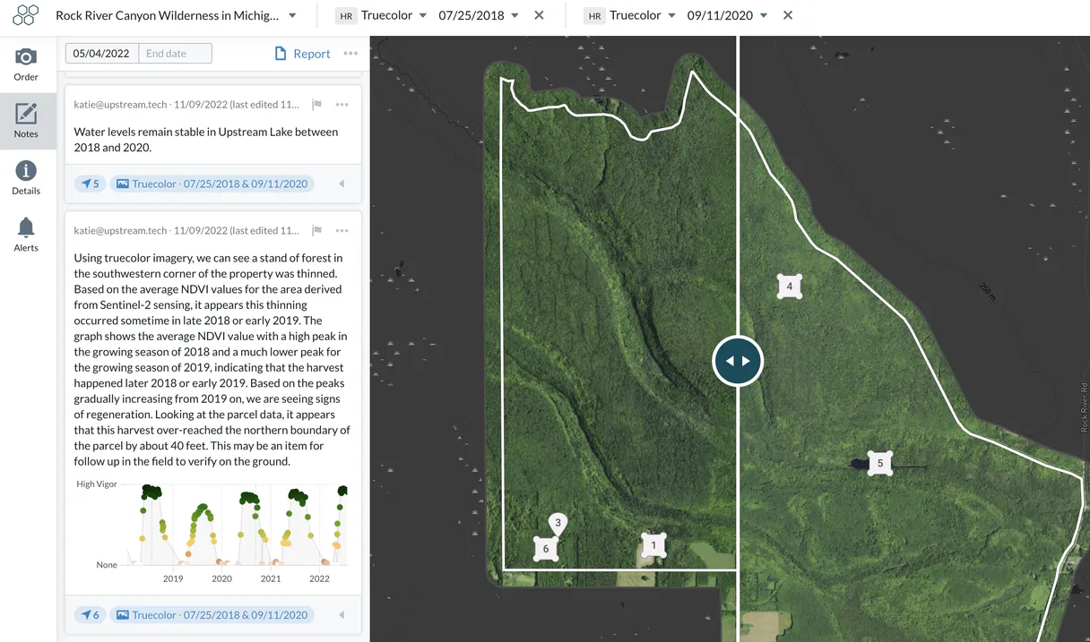
Environmental monitoring is all about tracking time. You don't have to leave the chat window to build an auditable timeline of site changes. If you need written field notes—the stuff people actually wrote down when they were out there—use list_project_notes. This lets you filter those observations by date for a specific project, so you can see exactly what was documented and when.
To get the granular details on what folks saw, use list_project_observations; this lists detailed records of every observation tied to a project. You can comb through all the historical documentation by targeting these tools against any given project ID.
Putting It All Together:
When you combine these calls, your AI client acts like it's sitting at the site with you. If you tell it, 'Show me all active projects and what imagery is available for the property associated with Project XYZ,' it pulls together a complete picture. You can see every portfolio (list_portfolios), confirm the API is live (check_api_health), get the project list (list_projects), pull down the latest satellite metadata (list_property_imagery)—and then, if you want to dig into the history of that spot, it pulls both the general notes (list_project_notes) and the specific observation records (list_project_observations).
It keeps your conservation data structured, verifiable, and immediately ready for whatever question you've got. You don't just get a list; you get the actionable context you need to make decisions.
019dd17e-5f1e-7390-9622-b30a4b1eb624 Here's how it actually works
The bottom line is that you use natural language commands to run complex geospatial queries across your entire environmental asset base.
Subscribe to this server and get your Upstream Tech Lens API Key.
Provide the key to your AI client (Claude, Cursor, etc.).
Ask a direct question: 'List all projects in the Amazon region' or 'Show me imagery for feat_10293'.
Who is this actually for?
Conservation Managers, Environmental Analysts, and Sustainability Directors. This is for the person who's tired of jumping between a database GUI, an imagery portal, and a spreadsheet just to compile one report on site changes. You need real-time data aggregation from diverse sources.
Runs queries comparing historical field notes against current satellite metadata for regulatory compliance reports.
Checks project status, lists all active portfolios, and confirms the API health before sending out operational tasks.
Maintains an organized record of environmental assets by listing projects and verifying organization profiles for board reports.
What Changes When You Connect
Check system status immediately. Use check_api_health to confirm the API is running before initiating any data retrieval, preventing failed jobs.
Manage assets by listing all projects using list_projects. This gives you a clean list of every site without needing to navigate multiple dashboards.
Track history with ease. Running list_project_notes pulls recorded field observations and notes, building an immediate timeline that's ready for reporting.
Compare images directly in the chat. Calling list_property_imagery shows you exactly what satellite layers are available for a property ID, saving time on manual checks.
Get site specifics instantly. Need to know the details of one feature? get_property_details pulls all necessary metadata into your agent's context.
See it in action
Compliance Check for a Portfolio
The analyst needs to verify environmental compliance across three sites. They first run list_projects to get the IDs, then use those IDs with get_property_details and list_property_imagery sequentially. The agent aggregates all metadata to create a single report on feature boundaries and available imagery.
Reviewing Site Changes
A manager wants to know if site 'ABC' has seen any changes since last quarter. They use list_project_notes and filter by date, cross-referencing the results with list_property_observations to ensure all physical reports match the recorded history.
Initial Project Scoping
A sustainability team member starts a new assessment. They first call list_portfolios to see which umbrella goals apply, then use that knowledge to run list_projects, quickly narrowing down the scope of work for the AI client.
Deep Dive into One Feature
The team needs all available data on a single feature ID. They start by running get_property_details to grab metadata, then follow up with list_property_imagery and get_organization_info to build a complete context file for the client.
The honest tradeoffs
Guessing field IDs
Trying to manually type in a complex property ID or portfolio name that you aren't sure is correct, leading to '404 Not Found' errors.
Always start by using list_projects and list_portfolios. This gives your AI agent the verified list of IDs and names it needs before attempting any detailed calls like get_property_details.
Ignoring API status
Running a complex data retrieval query when the service is experiencing an outage, wasting time until the job fails.
Always run check_api_health first. If it's green, then and only then should you proceed with resource-intensive calls like listing imagery or observations.
Mixing up notes vs. observations
Confusing a general project note (a text summary) with a structured observation (a measured data point).
Use list_project_notes for high-level narratives and summaries, but use list_project_observations when you need specific, quantified measurements or recorded metrics.
When It Fits, When It Doesn't
You should use this server if your job requires linking together multiple data types: satellite imagery metadata, structured field reports, and high-level project lists. If you're just doing basic CRUD operations on a single record (e.g., 'give me the name of property X'), you might be better off using a standard database connector tool instead.
However, if your workflow involves complex data assembly—like taking a list from list_projects, then getting imagery layers for each one via list_property_imagery, and finally pulling supporting notes with list_project_notes—this is the right place. Don't try to pull all that context through simple single-tool calls; let your AI client run them in sequence.
Questions you might have
How do I find all my environmental projects using list_projects? +
Just ask your agent to 'List all active environmental projects.' The list_projects tool runs immediately and gives you a clean, actionable roster of every project ID available in the system.
Can I check if the API is working before running any report? +
Yes. Run check_api_health. This simple call tells your agent instantly if the Upstream Lens connection is live, saving you from running expensive queries against a downed service.
Which tool do I use to find available satellite imagery? +
Use list_property_imagery and provide a specific property ID. This call tells you exactly which layers (Sentinel, Landsat) are available for that piece of land.
What's the difference between list_project_notes and list_project_observations? +
Project notes (list_project_notes) hold general text summaries written by field staff. Observations (list_project_observations) are typically structured, quantitative data points or metrics recorded at a specific time.
What does the `get_organization_info` tool retrieve about my Upstream Tech Lens account? +
The tool fetches core metadata for your entire organization. This helps confirm account configuration and verify basic credentials before you run larger, resource-intensive reports.
When should I use `get_property_details` instead of listing projects? +
Use this when you need the full metadata record for one specific feature. It retrieves deep details about a property—far beyond what general listings provide.
Can I use `list_project_notes` to filter observations by date range? +
Yes, you can specify an update date range when calling the tool. This lets you focus only on notes written between two specific dates for targeted analysis.
How does `list_portfolios` help manage my environmental assets? +
Portfolios group related projects and sites into a single container. Running this tool shows the high-level organizational structure of your conservation work.
Can I see if new satellite images are available for my project? +
Yes! Use the list_property_imagery tool and provide the Property ID. Your agent will retrieve all available imagery layers (Sentinel, Landsat, etc.) with their respective capture dates.
How do I retrieve field notes for a specific conservation project? +
Run the list_project_notes query with your Project ID. You can also provide an optional timestamp to filter only notes updated after a specific date.
Is it possible to see the geospatial metadata for a property feature? +
Absolutely. Use the get_property_details tool with the Feature ID to retrieve detailed geospatial data and metadata for any monitored property.
We've already built the connector for Upstream Lens. Just plug in your AI agents and start using Vinkius.
No hosting. No infrastructure. No complex setup.
All 8 tools are live and waiting.
You're up and running in seconds.
Gemini Vinkius gives your AI agents access to the full catalog of app connectors, all fully managed, secure, and enterprise-ready. One subscription, every tool you need.
Built, hosted, and secured by Vinkius. You just connect and go.