EOSDA Agriculture Satellite Data MCP Server for Pydantic AI 6 tools — connect in under 2 minutes
Pydantic AI brings type-safe agent development to Python with first-class MCP support. Connect EOSDA Agriculture Satellite Data through the Vinkius and every tool is automatically validated against Pydantic schemas — catch errors at build time, not in production.
ASK AI ABOUT THIS MCP SERVER
Vinkius supports streamable HTTP and SSE.
import asyncio
from pydantic_ai import Agent
from pydantic_ai.mcp import MCPServerHTTP

async def main():
    # Your Vinkius token — get it at cloud.vinkius.com
    server = MCPServerHTTP(url="https://edge.vinkius.com/[YOUR_TOKEN_HERE]/mcp")

    agent = Agent(
        model="openai:gpt-4o",
        mcp_servers=[server],
        system_prompt=(
            "You are an assistant with access to EOSDA Agriculture Satellite Data "
            "(6 tools)."
        ),
    )

    result = await agent.run(
        "What tools are available in EOSDA Agriculture Satellite Data?"
    )
    print(result.data)

asyncio.run(main())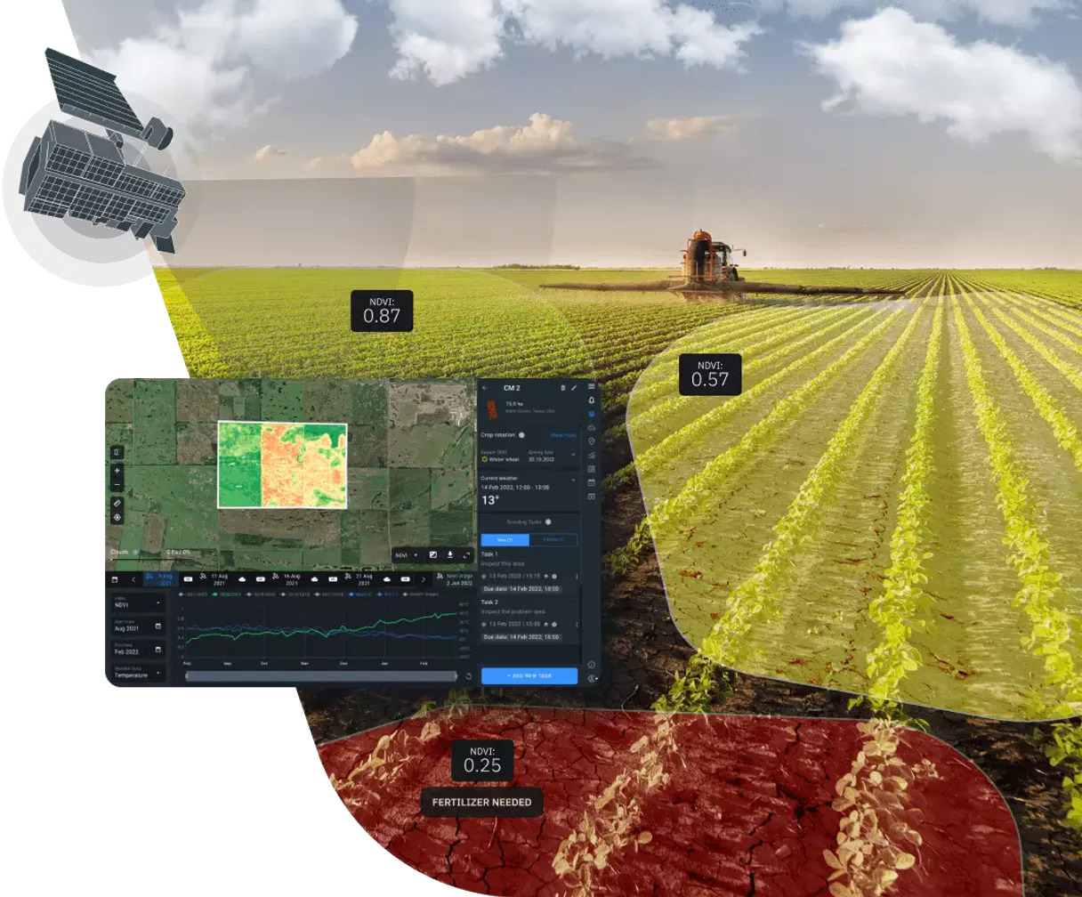
* Every MCP server runs on Vinkius-managed infrastructure inside AWS - a purpose-built runtime with per-request V8 isolates, Ed25519 signed audit chains, and sub-40ms cold starts optimized for native MCP execution. See our infrastructure
About EOSDA Agriculture Satellite Data MCP Server
Empower your AI agent with cutting-edge remote sensing capabilities via the EOSDA Agriculture MCP server. This integration provides instant access to high-resolution satellite data from Sentinel and Landsat missions, specifically processed for precision farming. Your agent can search for imagery across global datasets, calculate vegetation indices like NDVI, EVI, and MSAVI, and monitor soil moisture trends over time. Whether you are optimizing fertilizer application, auditing crop health, or monitoring land use, your agent acts as a dedicated agronomist and remote sensing specialist through natural conversation.
Pydantic AI validates every EOSDA Agriculture Satellite Data tool response against typed schemas, catching data inconsistencies at build time. Connect 6 tools through the Vinkius and switch between OpenAI, Anthropic, or Gemini without changing your integration code — full type safety, structured output guarantees, and dependency injection for testable agents.
What you can do
- Satellite Imagery Search — Search Sentinel-2, Landsat 8/9, and MODIS datasets by date and area of interest.
- Vegetation Indices — Trigger processing tasks for NDVI (health), EVI (biomass), and other critical indices.
- Health Monitoring — Retrieve processed results to identify areas of stress or high productivity in fields.
- Dataset Intelligence — Access technical specs for available satellites including resolution and revisit times.
- AOI Analysis — Input GeoJSON areas of interest to get localized intelligence for specific farms or regions.
The EOSDA Agriculture Satellite Data MCP Server exposes 6 tools through the Vinkius. Connect it to Pydantic AI in under two minutes — no API keys to rotate, no infrastructure to provision, no vendor lock-in. Your configuration, your data, your control.
How to Connect EOSDA Agriculture Satellite Data to Pydantic AI via MCP
Follow these steps to integrate the EOSDA Agriculture Satellite Data MCP Server with Pydantic AI.
Install Pydantic AI
Run pip install pydantic-ai
Replace the token
Replace [YOUR_TOKEN_HERE] with your Vinkius token
Run the agent
Save to agent.py and run: python agent.py
Explore tools
The agent discovers 6 tools from EOSDA Agriculture Satellite Data with type-safe schemas
Why Use Pydantic AI with the EOSDA Agriculture Satellite Data MCP Server
Pydantic AI provides unique advantages when paired with EOSDA Agriculture Satellite Data through the Model Context Protocol.
Full type safety: every MCP tool response is validated against Pydantic models, catching data inconsistencies before they reach your application
Model-agnostic architecture — switch between OpenAI, Anthropic, or Gemini without changing your EOSDA Agriculture Satellite Data integration code
Structured output guarantee: Pydantic AI ensures tool results conform to defined schemas, eliminating runtime type errors
Dependency injection system cleanly separates your EOSDA Agriculture Satellite Data connection logic from agent behavior for testable, maintainable code
EOSDA Agriculture Satellite Data + Pydantic AI Use Cases
Practical scenarios where Pydantic AI combined with the EOSDA Agriculture Satellite Data MCP Server delivers measurable value.
Type-safe data pipelines: query EOSDA Agriculture Satellite Data with guaranteed response schemas, feeding validated data into downstream processing
API orchestration: chain multiple EOSDA Agriculture Satellite Data tool calls with Pydantic validation at each step to ensure data integrity end-to-end
Production monitoring: build validated alert agents that query EOSDA Agriculture Satellite Data and output structured, schema-compliant notifications
Testing and QA: use Pydantic AI's dependency injection to mock EOSDA Agriculture Satellite Data responses and write comprehensive agent tests
EOSDA Agriculture Satellite Data MCP Tools for Pydantic AI (6)
These 6 tools become available when you connect EOSDA Agriculture Satellite Data to Pydantic AI via MCP:
create_vegetation_task
) for a specific area of interest. Returns a task ID that can be used with get_task_result to retrieve results. Use get_available_indices to see all available index types. Create a vegetation index calculation task (NDVI, EVI, etc.)
get_available_datasets
Use these dataset IDs for search_dataset and create_vegetation_task. Get list of available satellite datasets
get_available_indices
Use these index types with create_vegetation_task. Get list of available vegetation indices
get_task_result
Returns the processed vegetation index data, download URLs and status. Get the result of a vegetation index task
search_dataset
) within a date range and optional area of interest. Returns scene IDs, dates, cloud cover percentages and download URLs. Use get_available_datasets to see all dataset options. Search satellite imagery for a specific dataset
search_multi_dataset
g. Sentinel-2 and Landsat 8 together). Returns scenes from all requested datasets within the date range and area of interest. Search satellite imagery across multiple datasets
Example Prompts for EOSDA Agriculture Satellite Data in Pydantic AI
Ready-to-use prompts you can give your Pydantic AI agent to start working with EOSDA Agriculture Satellite Data immediately.
"Find Sentinel-2 images for my farm from the last month."
"Calculate the NDVI for this area: [GeoJSON coords]."
"What is the resolution of Landsat 8 satellite data?"
Troubleshooting EOSDA Agriculture Satellite Data MCP Server with Pydantic AI
Common issues when connecting EOSDA Agriculture Satellite Data to Pydantic AI through the Vinkius, and how to resolve them.
MCPServerHTTP not found
pip install --upgrade pydantic-aiEOSDA Agriculture Satellite Data + Pydantic AI FAQ
Common questions about integrating EOSDA Agriculture Satellite Data MCP Server with Pydantic AI.
How does Pydantic AI discover MCP tools?
MCPServerHTTP instance with the server URL. Pydantic AI connects, discovers all tools, and generates typed Python interfaces automatically.Does Pydantic AI validate MCP tool responses?
Can I switch LLM providers without changing MCP code?
Connect EOSDA Agriculture Satellite Data with your favorite client
Step-by-step setup guides for every MCP-compatible client and framework:
Anthropic's native desktop app for Claude with built-in MCP support.
AI-first code editor with integrated LLM-powered coding assistance.
GitHub Copilot in VS Code with Agent mode and MCP support.
Purpose-built IDE for agentic AI coding workflows.
Autonomous AI coding agent that runs inside VS Code.
Anthropic's agentic CLI for terminal-first development.
Python SDK for building production-grade OpenAI agent workflows.
Google's framework for building production AI agents.
Type-safe agent development for Python with first-class MCP support.
TypeScript toolkit for building AI-powered web applications.
TypeScript-native agent framework for modern web stacks.
Python framework for orchestrating collaborative AI agent crews.
Leading Python framework for composable LLM applications.
Data-aware AI agent framework for structured and unstructured sources.
Microsoft's framework for multi-agent collaborative conversations.
Connect EOSDA Agriculture Satellite Data to Pydantic AI
Get your token, paste the configuration, and start using 6 tools in under 2 minutes. No API key management needed.