TomTom Alternative MCP. Plan Routes and Resolve Geospatial Data via AI.
 Gemini
 Works with every AI agent you already use
…and any MCP-compatible client
Just plug in your AI agents and start using Vinkius.
TomTom Alternative connects global mapping, geocoding, and advanced routing data directly to your AI agent. Find addresses using fuzzy search, convert physical locations into precise coordinates, calculate optimal multi-stop routes factoring in real-time traffic, and retrieve map tiles for visualization—all via simple tool calls.
What your AI agents can do
Calculate advanced route
Figures out optimal paths for complex trips, supporting multiple stops or avoiding specific restricted areas.
Calculate route
Calculates a basic, fast route between two specified starting and ending points.
Fuzzy search
Performs quick searches for addresses or Points of Interest (POIs) even if the input text is misspelled or incomplete.
Search for street names and points of interest using flexible, partial text matches.
Turn a physical address into precise latitude and longitude pairs (geocoding).
Determine the fastest route between two specific points.
Model complex delivery or transit plans that involve multiple waypoints and advanced constraints.
Check current road conditions, including incidents and flow metrics, to adjust route timing.
Fetch the URL for a specific map tile image (basic or hybrid style) at given coordinates.
Ask AI about this MCP
Supported MCP Clients
Gemini Waiting for input…
TomTom Alternative MCP Server: 6 Tools for Geospatial Data
These tools let you find addresses, convert locations into coordinates, calculate optimal routes, check traffic, and visualize maps—all through simple tool calls.
019e5d61calculate advanced route
Figures out optimal paths for complex trips, supporting multiple stops or avoiding specific restricted areas.
019e5d61calculate route
Calculates a basic, fast route between two specified starting and ending points.
019e5d61fuzzy search
Performs quick searches for addresses or Points of Interest (POIs) even if the input text is misspelled or incomplete.
019e5d61geocode
Converts a textual address into precise, actionable geographic coordinates (lat/lon).
019e5d61get map tile
Returns the URL needed to display a map image for specific zoom levels and grid coordinates.
019e5d61get traffic incidents
Retrieves current data on traffic slowdowns, accidents, and flow rates in an area.
Choose How to Get Started
Build a custom MCP for your own tools, or connect a ready-made integration from our catalog.
Build Your Own
Turn any API into an MCP. Import a spec, define Agent Skills, or deploy with MCPFusion.
- Import from OpenAPI, Swagger, or YAML specs
- Create Agent Skills with progressive disclosure
- Deploy to edge with MCPFusion framework
- Built in DLP, auth, and compliance on every call
- Real time usage dashboard and cost metering
- Publish to catalog or keep private
Make Your AI Do More
Start with TomTom Alternative, then connect any of our 4,700+ other servers whenever your AI needs more. One click, no limits.
- Use this MCP plus 4,700+ others, all in one place
- Add new capabilities to your AI anytime you want
- Every connection is secured and compliant automatically
- Track usage and costs across all your servers
- Works with Claude, ChatGPT, Cursor, and more
- New servers added to the catalog every week
What you can do with this MCP connector
Look, this server is your go-to for anything location-based. It connects global mapping data and advanced routing directly to your AI agent so you don't gotta mess with external API keys or write complex code blocks just to figure out where something is. When your agent needs to know about geography—whether it’s finding a spot, calculating a trip, or drawing a map—it uses the tools we built in here.
When you need to find an address or a Point of Interest (POI), you don't gotta be perfect with spelling. Your agent just calls fuzzy_search, and it figures out addresses even if they're misspelled or incomplete. That's real useful. If you already have a physical street address, like '123 Main St,' your agent uses the geocode tool to convert that text into precise latitude/longitude coordinates.
This gives you actionable numbers ready for mapping or database storage.
For basic travel paths, calling calculate_route is quick and dirty: it figures out the fastest route between just two points—a start and an end. But if your trip's more complicated? Say, a multi-stop delivery run? You gotta use calculate_advanced_route. This handles complex logistics plans that involve multiple waypoints or require avoiding specific restricted zones.
It models those big, messy transit plans for you.
Before it even plots the route, though, your agent checks what's happening on the actual roads. It calls get_traffic_incidents to pull in real-time data on traffic slowdowns, accidents, and current flow rates across an area. This feed tells the routing tools how accurate their time estimates are, making sure you don't plan a trip through gridlock.
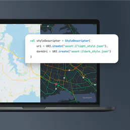
When it’s time to visualize all this stuff—the route, the stops, the traffic—your agent uses get_map_tile. You give it specific zoom levels and grid coordinates, and it returns the URL needed to display that exact map image (basic or hybrid style) right where you need it.
Here's how they work together. If your task is planning a major logistics run, your agent first uses fuzzy_search to confirm all those stop addresses. Next, it runs geocode on every single one of them to get precise coordinates. Then, it calls get_traffic_incidents for the whole area. Finally, it feeds that data into calculate_advanced_route, which spits out the optimal path, and then get_map_tile draws the final picture for you.
It’s a full loop of location intelligence that runs clean through simple tool calls.
You'll use this server to resolve addresses, convert coordinates, calculate basic travel paths, plan multi-stop logistics routes, check real-time traffic conditions, and generate map images—all without leaving your AI agent's environment. It’s tight. You just let your agent talk naturally, and it handles the dirty work of mapping and routing.
How TomTom Alternative MCP Works
- 1 First, subscribe to the TomTom Alternative MCP Server and provide your API Key in the client configuration.
- 2 Next, prompt your AI agent with a request (e.g., 'What's the best route from X to Y?'). The agent selects the necessary tools (
geocode,get_traffic_incidents, etc.). - 3 Finally, the server executes the tool sequence and returns structured data—coordinates, routes, or map URLs—to your AI client for final display.
The bottom line is that it lets your agent access complex mapping logic without you having to write any underlying API calls.
Who Is TomTom Alternative MCP For?
Logistics coordinators, field service managers, and geospatial developers. You're the person who stares at spreadsheets full of addresses and knows that 'optimal routing' isn't a suggestion—it's mission-critical. If you spend time manually checking map APIs or trying to stitch together address data in multiple tools, this is for you.
Uses calculate_advanced_route and get_traffic_incidents to plan daily delivery routes that account for vehicle capacity, multiple stops, and real-time traffic delays.
Runs fuzzy_search and geocode on large lists of potential addresses to validate location data before purchase or construction planning.
Integrates the mapping tools into a chat interface, calling get_map_tile and calculate_route endpoints directly from code snippets within their IDE.
What Changes When You Connect
- Accurate Address Resolution: Use
fuzzy_searchto find locations when users only remember part of an address or misspells a street name. This prevents dead ends in your workflow, ensuring the agent always gets a usable starting point. - Dynamic Route Optimization: Don't just calculate A-to-B travel time. Combine
calculate_routewithget_traffic_incidentsto give users an estimate that reflects current road conditions—it’s not guesswork. - Complex Logistics Handling: For deliveries involving 10+ stops, use
calculate_advanced_route. This tool handles the multi-stop logic and specific constraints (like avoiding country vignettes) far better than simple A-to-B tools. - Visualization on Demand: Instead of just getting coordinates, use
get_map_tileto pull a map image URL. Your agent can then present not only the route data but also a visual representation in one step. - Precise Data Foundation: The
geocodetool ensures that whatever input—from an address string or a user's rough coordinates—gets converted into verifiable, clean geographic points for any backend process.
Real-World Use Cases
The Dispatcher Needs Multi-Stop Planning
A fleet manager needs to plan 15 stops across three counties. Instead of running 14 separate A-to-B calculations, the agent uses calculate_advanced_route. It handles the entire sequence, optimizes for minimum travel time, and builds a single itinerary, saving hours of manual computation.
Validating New Store Locations
A developer needs to check if 50 potential addresses are valid and get their coordinates. They pipe the list into geocode. The agent returns structured latitude/longitude pairs, which can immediately feed into a database or map rendering tool without manual cleanup.
Real-Time Navigation Support
A user asks for directions during rush hour. The agent first calls get_traffic_incidents to check current flow and then runs calculate_route. The result isn't just the distance; it's a time estimate adjusted by the real-time congestion data.
Generating an Interactive Map Report
A client needs a map showing three locations (origins/destinations). The agent runs geocode for all points, and then uses get_map_tile with the resulting coordinates to generate a single, embeddable map image URL for their report.
The Tradeoffs
Treating Coordinates as Addresses
Sending raw latitude/longitude pairs (e.g., 52.509,13.429) to fuzzy_search expecting a full address result. This tool requires text input.
→
Always run the coordinates through geocode first if you need an official human-readable street address, or use the raw pair directly with routing tools like calculate_route. Don't mix inputs.
Calculating routes without traffic context
Calling only calculate_route for a cross-city journey during known rush hour. The resulting time estimate will be wildly inaccurate.
→
Always check current conditions first. Call get_traffic_incidents before running any route calculation tool (calculate_route or calculate_advanced_route) to get the most accurate travel time.
Assuming a single tool does everything
Trying to get coordinates, calculate a multi-stop route, and draw a map from one API call. This is impossible with separate tools.
→
You need a sequence. Use geocode -> calculate_advanced_route (for the data) -> get_map_tile (for the visualization). It's always a chain.
When It Fits, When It Doesn't
Use this MCP Server if your core problem revolves around spatial relationships: 'Where is it?' or 'How do I get there?'
DO use it when: You need to validate user input (fuzzy search), convert ambiguous locations into machine-readable coordinates (geocode), or manage complex, multi-waypoint logistics. If the travel time must account for traffic, you need get_traffic_incidents feeding into your routing calls.
DO NOT use it when: Your problem is purely data management (e.g., updating a user profile name) or involves non-geospatial logic. For simple lookups that don't involve location, stick to general database tools instead of running through the geocoding stack.

Independent Platform Disclaimer: Vinkius is an independent platform and is not affiliated with, endorsed by, sponsored by, verified by, or otherwise authorized by TomTom. All third-party trademarks, logos, and brand names are the property of their respective owners. Their use on this website is strictly for informational purposes to identify service compatibility and interoperability.
VINKIUS INFRASTRUCTURE
Cloud Hosted
Managed infra
V8 Isolated
Sandboxed per request
Zero-Trust Proxy
No stored credentials
DLP Enforced
Policy on every call
GDPR Compliant
EU data residency
Token Compression
~60% cost reduction
Works with Claude, ChatGPT, Cursor, and more
The Model Context Protocol standardizes how applications expose capabilities to LLMs. Instead of operating in isolation, your AI gains direct access to external platforms, live data, and real-world actions through secure, standardized connections.
This server provides 6 capabilities that interface natively with Claude, ChatGPT, Cursor, and any MCP client. No middleware. No custom integration required.
Available Capabilities
Trying to figure out locations shouldn't require multiple API calls and guesswork.
Today, if you need a precise address for calculation, you might start with fuzzy searching, then run that result through geocoding just to get coordinates, and finally use those coordinates in the routing tool. It’s three separate steps, three potential points of failure, and lots of copy-pasting.
With this MCP Server, your agent handles it all. You ask for a location, and the agent automatically runs `fuzzy_search` to nail down the target, uses `geocode` for clean coordinates, and hands off that data straight into the router. You get one clean result.
TomTom Alternative MCP Server: Calculate routes and map tiles.
Before, planning a complex route meant manually checking for traffic conditions in a separate dashboard and then adjusting the estimated time. You had to run multiple services just to get an accurate ETA for your team.
Now, the agent runs `get_traffic_incidents` first. It feeds those real-time details directly into `calculate_advanced_route`. The result is a single, accurate travel plan—no guesswork.
Common Questions About TomTom Alternative MCP
How do I use the fuzzy_search tool with TomTom Alternative? +
Use fuzzy_search when you don't have an exact address or POI name. Just input a partial description, and the tool finds the best match for addresses or points of interest.
Does calculate_advanced_route handle traffic? +
Yes. calculate_advanced_route supports integrating real-time data. It combines inputs from tools like get_traffic_incidents to provide optimized paths based on current road conditions.
What is the difference between calculate_route and calculate_advanced_route? +
calculate_route handles simple A-to-B journeys. Use calculate_advanced_route when you need more control—like specifying multiple required stops or telling the route to avoid certain areas.
Can I use get_map_tile without coordinates? +
No. The get_map_tile tool requires specific zoom levels and X/Y tile coordinates (the XYZ grid system) to generate the map image URL. You must provide those parameters.
How do I handle authentication for the `geocode` tool? +
You must provide a valid TomTom API Key when making calls. Your AI client handles passing this key securely, so you don't need to manage it directly in your prompts.
What happens if I get too many requests using `get_traffic_incidents`? +
If you exceed the API rate limit, you will receive a 429 error. Implement exponential backoff in your agent workflow to automatically retry the request later.
Does `calculate_route` support specifying vehicle types? +
No, the standard calculate_route function only calculates basic travel times between two points. For specialized profiles like trucks or bicycles, use the calculate_advanced_route tool instead.
Can I get map tiles for a specific region using `get_map_tile`? +
Yes, you specify the desired geographical area by providing the X and Y coordinates along with your target zoom level. The tile URL format requires these three parameters.
Can I search for a place using just a name like 'Coffee Shop'? +
Yes! Use the fuzzy_search tool. It allows you to search for points of interest, streets, and addresses using free-text queries.
Does the routing tool take real-time traffic into account? +
Yes, by default the calculate_route tool uses real-time traffic data to provide the most accurate travel times and paths.
How can I get the latitude and longitude for a specific address? +
You can use the geocode tool. Simply provide the address string, and it will return the geographic coordinates.
Use it with your favorite AI tools
Connect this server to Cursor, Claude, VS Code, and more.
More in this category
ArcGIS
Automate mapping and spatial analysis via ArcGIS — perform geocoding, route solving, vehicle routing, and calculate origin-destination matrices from any AI agent.

Sunrise-Sunset
Get precise sunrise, sunset, and twilight times for any location on Earth using latitude and longitude coordinates.
TomTom Parking Availability
Search parking spots — audit locations and availability via AI.
You might also like

Nutrient Workflow
Build document workflows with PDF viewing, editing, annotation, and digital signatures embedded directly into your applications.

OptimoRoute
Optimize delivery routes via OptimoRoute — create orders, track driver locations, and manage route planning directly from any AI agent.

New York Times
Access top stories, article search, best-seller lists, and movie reviews via the NYTimes API.