EOSDA Agriculture Satellite Data MCP Server
Precision agriculture satellite intelligence — access NDVI, soil moisture, and crop health via AI.
Ask AI about this MCP Server
Vinkius AI Gateway supports streamable HTTP and SSE.
Works with every AI agent you already use
…and any MCP-compatible client
What is the EOSDA Agriculture Satellite Data MCP Server?
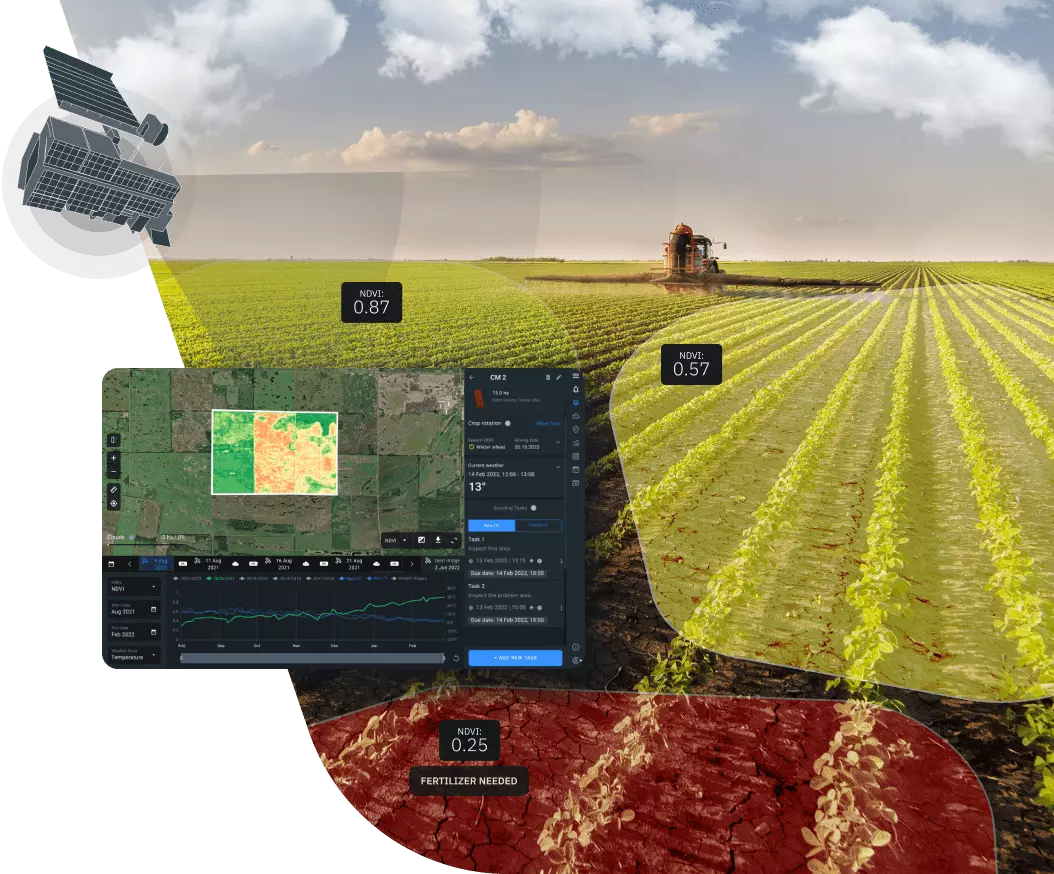
The EOSDA MCP Server gives AI agents like Claude, ChatGPT, and Cursor direct access to EOSDA. Precision agriculture satellite intelligence — access NDVI, soil moisture, and crop health via AI. Powered by the Vinkius AI Gateway — no API keys, no infrastructure, connect in under 2 minutes.
EOSDA MCP Server: see your AI Agent in action
Built-in capabilities (6)
create_vegetation_task
) for a specific area of interest. Returns a task ID that can be used with get_task_result to retrieve results. Use get_available_indices to see all available index types. Create a vegetation index calculation task (NDVI, EVI, etc.)
get_available_datasets
Use these dataset IDs for search_dataset and create_vegetation_task. Get list of available satellite datasets
get_available_indices
Use these index types with create_vegetation_task. Get list of available vegetation indices
get_task_result
Returns the processed vegetation index data, download URLs and status. Get the result of a vegetation index task
search_dataset
) within a date range and optional area of interest. Returns scene IDs, dates, cloud cover percentages and download URLs. Use get_available_datasets to see all dataset options. Search satellite imagery for a specific dataset
search_multi_dataset
g. Sentinel-2 and Landsat 8 together). Returns scenes from all requested datasets within the date range and area of interest. Search satellite imagery across multiple datasets
What this connector unlocks
Empower your AI agent with cutting-edge remote sensing capabilities via the EOSDA Agriculture MCP server. This integration provides instant access to high-resolution satellite data from Sentinel and Landsat missions, specifically processed for precision farming. Your agent can search for imagery across global datasets, calculate vegetation indices like NDVI, EVI, and MSAVI, and monitor soil moisture trends over time. Whether you are optimizing fertilizer application, auditing crop health, or monitoring land use, your agent acts as a dedicated agronomist and remote sensing specialist through natural conversation.
What you can do
- Satellite Imagery Search — Search Sentinel-2, Landsat 8/9, and MODIS datasets by date and area of interest.
- Vegetation Indices — Trigger processing tasks for NDVI (health), EVI (biomass), and other critical indices.
- Health Monitoring — Retrieve processed results to identify areas of stress or high productivity in fields.
- Dataset Intelligence — Access technical specs for available satellites including resolution and revisit times.
- AOI Analysis — Input GeoJSON areas of interest to get localized intelligence for specific farms or regions.
How it works
1. Subscribe to this server
2. Enter your EOSDA API Key (from EOS Data Analytics dashboard)
3. Start managing your precision agriculture data from Claude, Cursor, or any MCP-compatible client
Who is this for?
- Agronomists & Farm Managers — monitor field performance and crop health without manual site visits.
- Ag-Tech Developers — integrate remote sensing data into custom farming applications.
- Sustainability Officers — track land use changes and vegetation trends over large geographic areas.
- Researchers — access historical and near real-time satellite data for agricultural studies.
Frequently asked questions
Give your AI agents the power of EOSDA
Access EOSDA and 2,500+ MCP servers — ready for your agents to use, right now. No glue code. No custom integrations. Just plug Vinkius AI Gateway and let your agents work.