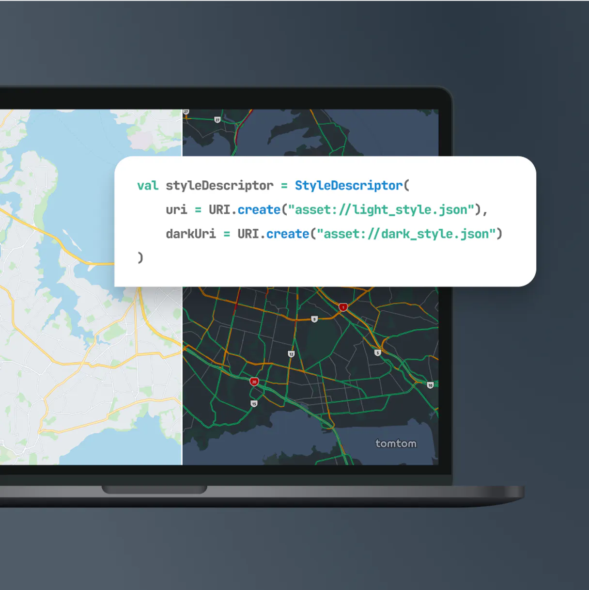
TomTom MCP. Map routes and check live traffic in a single query.
 Gemini
 Works with every AI agent you already use
…and any MCP-compatible client
Just plug in your AI agents and start using Vinkius.
TomTom equips your AI agent with global mapping, routing, and real-time traffic data. You convert complex addresses into lat/lon coordinates instantly, calculate exact travel time between points, or map live accident zones using a single chat query.
What your AI agents can do
Autocomplete place search
It suggests potential locations as you type a partial address string.
Calculate reachable range
It maps out the maximum area your fleet can cover based on a starting point and time limit.
Calculate route
It returns the path, total distance, and travel time between two given coordinates.
You run calculate_route() to get a polyline path, total distance, and predicted travel time between two points.
Using fuzzy_geocoding or structured_geocoding, you convert vague physical addresses into precise latitude/longitude pairs for mapping.
You call search_poi_by_category() to find specific types of locations (like hospitals or gas stations) near a given coordinate.
You check for active incidents using get_traffic_incidents() within a bounding box, or measure flow speed on one road segment with get_traffic_flow_segment().
You use calculate_reachable_range() to map the total area (polygonal limits) a fleet can cover within a specific time budget.
Ask AI about this MCP
Supported MCP Clients
Gemini Waiting for input…
TomTom: 10 Tools for Mapping & Routing
Calculate routes, estimate travel times, check real-time traffic flow, or convert addresses to coordinates using these ten geospatial tools.
019d7614autocomplete place search
It suggests potential locations as you type a partial address string.
019d7614calculate reachable range
It maps out the maximum area your fleet can cover based on a starting point and time limit.
019d7614calculate route
It returns the path, total distance, and travel time between two given coordinates.
019d7614fuzzy geocoding
It converts a physical address string into geographic coordinates even if the address isn't perfectly formatted.
019d7614get poi details
It pulls rich metadata, like hours and contacts, for an existing Point of Interest ID.
019d7614get traffic flow segment
It reports the speed and quality of traffic for a specific stretch of road defined by coordinates.
019d7614get traffic incidents
It finds active traffic incidents (accidents, jams) within any specified geographic box.
019d7614reverse geocoding
It converts raw latitude/longitude coordinates back into a human-readable street address.
019d7614search poi by category
It finds nearby points of interest, such as gas stations or schools, using a category name and center coordinate.
019d7614structured geocoding
It performs geocoding by requiring explicit address components like country code or zip code for maximum accuracy.
Choose How to Get Started
Build a custom MCP for your own tools, or connect a ready-made integration from our catalog.
Build Your Own
Turn any API into an MCP. Import a spec, define Agent Skills, or deploy with MCPFusion.
- Import from OpenAPI, Swagger, or YAML specs
- Create Agent Skills with progressive disclosure
- Deploy to edge with MCPFusion framework
- Built in DLP, auth, and compliance on every call
- Real time usage dashboard and cost metering
- Publish to catalog or keep private
Make Your AI Do More
Start with TomTom, then connect any of our 4,700+ other servers whenever your AI needs more. One click, no limits.
- Use this MCP plus 4,700+ others, all in one place
- Add new capabilities to your AI anytime you want
- Every connection is secured and compliant automatically
- Track usage and costs across all your servers
- Works with Claude, ChatGPT, Cursor, and more
- New servers added to the catalog every week
What you can do with this MCP connector
This server equips your AI client with global mapping, routing, and real-time traffic data from TomTom. You'll convert complex addresses into coordinates instantly, calculate exact travel time between points, or map live accident zones using a single chat query.
Geocoding: Turning Street Names into Numbers
When you don't have precise latitude/longitude pairs, these tools get the job done. If you're working with messy addresses—the kind that aren't perfectly formatted—you can use fuzzy_geocoding to reliably convert those vague physical address strings into usable geographic coordinates.
For mission-critical applications where accuracy matters most, stick with structured_geocoding.
This tool demands explicit components like a country code or zip code, guaranteeing maximum precision when you need it. If your input is just raw lat/lon, but you need to know what street that point sits on, run reverse_geocoding; it'll turn those numbers back into a readable address.
Before you even start mapping, you can get ahead of the game with autocomplete_place_search.
As soon as your agent starts typing a partial address string, this tool suggests potential locations right away, saving time and preventing bad data inputs.
Routing: Calculating Paths and Time Estimates
Need to know how long it'll take to get from point A to point B? You run calculate_route() to get the full picture. This function returns a polyline path, the total distance traveled, and a predicted travel time between two given coordinates.
When planning for large groups or fleets, you use calculate_reachable_range().
It maps out the maximum area—the actual polygonal limits—your whole fleet can cover starting from a specific point within a set time budget.
Live Traffic Monitoring: Seeing What's Happening on the Road
Traffic conditions change minute by minute, and your agent needs to know it. You check for active traffic incidents (accidents, construction closures, major jams) using get_traffic_incidents(). This tool requires you to define a specific bounding box where you want to look for trouble.
To measure the actual flow of vehicles on one stretch of road, you use get_traffic_flow_segment().
You input coordinates defining that segment, and it reports both the current speed and the quality of traffic there.
Discovery: Finding Points of Interest (POIs)
Sometimes you don't care where they are, just what kind of place they are. To find specific types of locations—like hospitals, gas stations, or schools—you call search_poi_by_category(). You pass in a category name and the center coordinate to get nearby results.
If you already have an ID for a POI that was found elsewhere, don't just rely on its basic listing.
Use get_poi_details() to pull rich metadata about it, like operating hours or contact numbers.
How TomTom MCP Works
- 1 Add this component to your workflow and grab a secure API token from the TomTom Developer Portal.
- 2 Your AI client sends the request (e.g., coordinates, category name, time budget) formatted for the specific tool.
- 3 The server executes the query against global mapping data and returns structured JSON containing routes, addresses, or traffic details.
The bottom line is that you send location data to your agent, and it runs TomTom's engine to give you a precise, actionable result.
Who Is TomTom MCP For?
Logistics Engineers who hate calculating routes in spreadsheets. App Developers building field service tools who need real-time POI data. Fleet Managers tracking vehicle compliance and unexpected road delays. If your job involves movement, scheduling, or mapping physical space, this is for you.
You run calculate_reachable_range() to test route shedding options, or use structured_geocoding to verify addresses before building a new routing model.
You implement search_poi_by_category() to automatically find the nearest open hospital or fuel station when an agent reaches a job site.
You query get_traffic_incidents() in real-time, allowing your agent to calculate alternative routes and adjust delivery schedules on the fly.
What Changes When You Connect
- Avoid guesswork on locations. Instead of guessing coordinates, run
fuzzy_geocodingto convert any messy address string into exact lat/lon pairs automatically. - Plan for contingencies. Use
calculate_reachable_range()to know the actual boundaries of your service area before dispatching a team, preventing wasted trips. - Get immediate route data. Running
calculate_route()gives you the full polyline and travel time instantly, cutting out spreadsheet calculations. - Stay ahead of delays. Check for accidents using
get_traffic_incidents()across a bounding box—you see major jams before your agent even reaches them. - Find what you need fast. Instead of manually searching Google Maps, call
search_poi_by_category()to get contact info and hours for nearby facilities.
Real-World Use Cases
A delivery route needs optimizing around an accident.
The agent checks the area using get_traffic_incidents() and finds a major lane blockage. It then runs calculate_route() with the new constraints, automatically updating the estimated arrival time for the dispatcher.
We need to know if our service van can reach the site by 3 pm.
You use calculate_reachable_range(), feeding in the vehicle's starting point and a maximum travel duration. The tool returns the exact polygon of coverage, confirming feasibility.
We are building an internal directory for client sites.
Instead of manual data entry, you run search_poi_by_category() near a zip code to programmatically pull details (like phone numbers or opening hours) for all nearby utility providers.
Converting unstructured text addresses into usable data.
A customer service ticket only has 'Near the old library downtown.' You pass this string to fuzzy_geocoding() which returns precise coordinates, allowing the agent to generate a specific map link.
The Tradeoffs
Guessing Coordinates
A user types 'Washington D.C., near Union Station' and tries to manually estimate lat/lon.
→
Don't guess. Use fuzzy_geocoding() or, if you have the country code, use structured_geocoding() to turn any address string into precise coordinates.
Ignoring Traffic Boundaries
Checking for traffic across a whole city without defining a specific area.
→
Always constrain your query. Pass min/max lat/lon coordinates when calling get_traffic_incidents() to limit the scan to exactly where you need it.
Missing Context for POIs
Asking 'What hospitals are near me?' without knowing your current location.
→
You must provide a center coordinate. Use search_poi_by_category() with both the category (e.g., 'hospital') and the required coordinates.
When It Fits, When It Doesn't
Use this server if your problem involves movement or location geometry. If you need to know how long it takes to get from A to B, what's around point C, or how far a vehicle can go by 4 PM, use TomTom. Don't use it if all you need is basic data lookup—for example, if you just want to fetch an employee record ID from a database; that requires a different kind of API tool. If your primary goal is simply converting raw lat/lon pairs into street names, reverse_geocoding handles that specific job, but for anything involving time, distance, or traffic flow, this suite is necessary.
Independent Platform Disclaimer: Vinkius is an independent platform and is not affiliated with, endorsed by, sponsored by, verified by, or otherwise authorized by TomTom. All third-party trademarks, logos, and brand names are the property of their respective owners. Their use on this website is strictly for informational purposes to identify service compatibility and interoperability.
VINKIUS INFRASTRUCTURE
Cloud Hosted
Managed infra
V8 Isolated
Sandboxed per request
Zero-Trust Proxy
No stored credentials
DLP Enforced
Policy on every call
GDPR Compliant
EU data residency
Token Compression
~60% cost reduction
Works with Claude, ChatGPT, Cursor, and more
The Model Context Protocol standardizes how applications expose capabilities to LLMs. Instead of operating in isolation, your AI gains direct access to external platforms, live data, and real-world actions through secure, standardized connections.
This server provides 10 capabilities that interface natively with Claude, ChatGPT, Cursor, and any MCP client. No middleware. No custom integration required.
Available Capabilities
Dealing with location data shouldn't feel like a detective novel.
Today, figuring out a simple route means jumping between Google Maps, manual address lookups in your CRM, and then cross-referencing traffic updates on another dashboard. You spend time copy/pasting coordinates, verifying if the fuzzy address will even work, or just guessing which tool to hit first.
With this MCP server, you describe the goal—'Calculate a route from X to Y, checking for accidents.' The agent runs `calculate_route()` and `get_traffic_incidents()` simultaneously. You get one clean, definitive answer.
TomTom makes real-time traffic data instant.
Before, checking live road conditions meant opening a map service and zooming in until you found the incident marker. If the accident was outside your manual view, you were blind. The process was slow, reactive, and incomplete.
Now, by using `get_traffic_incidents()` with defined boundaries, your agent performs a precise scan of that exact area. You get real-time JSON data on accidents or construction zones—it's proactive, accurate, and immediate.
Common Questions About TomTom MCP
How do I convert an address to coordinates using TomTom MCP Server? +
You use fuzzy_geocoding() for addresses that are vague or poorly formatted. If you have highly structured data (like a country code and zip), use the more reliable structured_geocoding().
What is the difference between calculate_route and fuzzy_geocoding in TomTom MCP Server? +
fuzzy_geocoding converts an address string into coordinates. calculate_route takes those resulting coordinates and calculates the actual path, distance, and time needed to get there.
Can I check for traffic without knowing exact lat/lon points? +
No. All real-time services require boundaries. You must provide minimum and maximum latitude/longitude coordinates when calling get_traffic_incidents() to define the area you want scanned.
How do I find nearby gas stations using TomTom MCP Server? +
You run search_poi_by_category(). You must provide both the category name ('fuel' or 'gas station') and a center coordinate near where you need to search.
When should I use `structured_geocoding` instead of `fuzzy_geocoding`? +
Use structured_geocoding when you have explicit address components like zip codes and country names. This method requires defined parameters (e.g., street, city) for maximum accuracy, whereas fuzzy matching handles poorly formatted or incomplete string inputs.
How does the TomTom MCP Server handle authentication? +
You connect by providing a secure API token generated from the TomTom Developer Portal. Your AI agent uses this key to authorize all tool calls, ensuring that your requests are tracked and billed correctly.
What specific data does `get_poi_details` return for a Point of Interest? +
It returns rich metadata about a location identified by its unique ID. Expect detailed information like operating hours, full contact numbers, and comprehensive business descriptions.
What inputs are required for `calculate_reachable_range` to set accurate travel boundaries? +
This tool requires two specific pieces of data: the center coordinates (latitude/longitude) and a precise time budget in seconds. This calculation determines all areas physically reachable within that defined temporal limit.
Where and how do I extract my TomTom API Key? +
Log into your account at the developer.tomtom.com portal. Go to the dashboard console and select Keys (or My Dashboard). Either use your default developer API Key or click Add new Key for this specific agent usage. Copy the entire cryptographic string and insert it below securely.
Can the agent interact with or update the maps itself? +
No. The integration exclusively lists and pulls read-only endpoints (timelines, distances, addresses). The AI agent leverages TomTom merely to process geographic conversions securely; it lacks parameters capable of feeding corruptions or modifying raw data maps.
Should I secure my TomTom API Key? +
Yes. It is highly recommended to set a Domain Whitelist in your key management settings on the TomTom developer portal. This restricts the use of your key to specific domains, preventing unauthorized use or rate limit exhaustion.
Use it with your favorite AI tools
Connect this server to Cursor, Claude, VS Code, and more.
More in this category
Ship24
Track shipments from 1200+ carriers worldwide with a universal tracking API that gives real-time delivery status updates.

Netease Yunxin IM
Equip your AI Agent with Netease Yunxin to massively manage Live Chat Rooms, moderate IM participants, and broadcast messages.

Teambition
Collaborative project management platform by Alibaba — manage tasks, projects, and team workflows via AI.
You might also like

AcademyOcean
LMS for smart corporate training — manage learners, courses, and training progress via AI.

Blockchair (Universal Blockchain Search Engine & API)
Query blocks, transactions, and addresses across multiple blockchains like Bitcoin and Ethereum using Blockchair's universal API.
QuickBooks Online
Connect QuickBooks to AI — query invoices, manage customers, run financial reports, and automate accounting workflows.