Bring Location Services
to LlamaIndex
Create your Vinkius account to connect Open-Meteo Geocoding & Elevation to LlamaIndex and start using all 3 AI tools in minutes. Fully managed, enterprise secure, and ready to use without writing a single line of code. No hosting, no server setup — just connect and start using.
Compatible with every major AI agent and IDE
 Gemini
What is the Open-Meteo Geocoding & Elevation MCP Server?
The essential utility server that powers location-aware AI agents.
What you can do
- Global Search — Find any city or village by name in any language, get lat/lon, elevation, population, timezone, and postal codes
- Terrain Elevation — Get precise elevation in meters for any GPS coordinate using a 90-meter digital elevation model
- Country Filtering — Search locations within specific countries using ISO codes
Who is this for?
Developers, data engineers, travel apps, logistics platforms, and any AI agent that needs to convert place names into actionable coordinates.
Built-in capabilities (3)
Get terrain elevation for any coordinates
Supports any language. Search for cities and locations globally
g., US, BR, DE, FR). Search locations filtered by country
Why LlamaIndex?
LlamaIndex agents combine Open-Meteo Geocoding & Elevation tool responses with indexed documents for comprehensive, grounded answers. Connect 3 tools through Vinkius and query live data alongside vector stores and SQL databases in a single turn. ideal for hybrid search, data enrichment, and analytical workflows.
- —
Data-first architecture: LlamaIndex agents combine Open-Meteo Geocoding & Elevation tool responses with indexed documents for comprehensive, grounded answers
- —
Query pipeline framework lets you chain Open-Meteo Geocoding & Elevation tool calls with transformations, filters, and re-rankers in a typed pipeline
- —
Multi-source reasoning: agents can query Open-Meteo Geocoding & Elevation, a vector store, and a SQL database in a single turn and synthesize results
- —
Observability integrations show exactly what Open-Meteo Geocoding & Elevation tools were called, what data was returned, and how it influenced the final answer
Open-Meteo Geocoding & Elevation in LlamaIndex
Why run Open-Meteo Geocoding & Elevation with Vinkius?
The Open-Meteo Geocoding & Elevation connection runs on our fully managed, secure cloud infrastructure. We handle the hosting, maintenance, and security so you don't have to deal with servers or code. All 3 tools are ready to work instantly without any complex setup.
You stay in complete control of your data. Your AI only accesses the information you approve, keeping your sensitive passwords and private details completely safe. Plus, with automatic optimizations, your AI works faster and more efficiently.
* Every connection is hosted and maintained by Vinkius. We handle the security, updates, and infrastructure so you don't have to write code or manage servers. See our infrastructure
Over 4,000 integrations ready for AI agents
Explore a vast library of pre-built integrations, optimized and ready to deploy.
Connect securely in under 30 seconds
Generate tokens to authenticate and link external services in a single step.
Complete visibility into every agent action
Audit live requests, latency, success rates, and active security compliance policies.
Optimize spending and track token ROI
Analyze real-time token consumption and cost metrics detailed by connection.


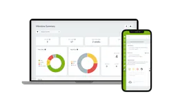
Explore our live AI Agents Analytics dashboard to see it all working
This dashboard is included when you connect Open-Meteo Geocoding & Elevation using Vinkius. You will never be left in the dark about what your AI agents are doing with your tools.
Open-Meteo Geocoding & Elevation and 4,000+ other AI tools. No hosting, no code, ready to use.
Professionals who connect Open-Meteo Geocoding & Elevation to LlamaIndex through Vinkius don't need to write code, manage servers, or worry about security. Everything is pre-configured, secure, and runs automatically in the background.
Raw MCP | Vinkius | |
|---|---|---|
| Ready-to-use MCPs | Find and configure each manually | 4,000+ MCPs ready to use |
| Connection Setup | Manual coding & server setup | 1-click instant connection |
| Server Hosting | You host it yourself (needs 24/7 uptime) | 100% hosted & managed by Vinkius |
| Security & Privacy | Stored in plaintext config files | Bank-grade encrypted vault |
| Activity Visibility | Blind execution (no logs or tracking) | Live dashboard with real-time logs |
| Cost Control | Runaway AI token spend risk | Automatic budget limits |
| Revoking Access | Must delete files or code to stop | 1-click disconnect button |
How Vinkius secures
Open-Meteo Geocoding & Elevation for LlamaIndex
Every request between LlamaIndex and Open-Meteo Geocoding & Elevation is protected by our secure gateway. We automatically keep your sensitive data private, prevent unauthorized access, and let you disconnect instantly at any time.
Frequently asked questions
What data source powers the geocoding?
Location data is sourced from GeoNames — the world's largest geographical database with over 25 million place names. Elevation uses a 90-meter digital elevation model (DEM) for terrain precision.
How does LlamaIndex connect to MCP servers?
Use the MCP client adapter to create a connection. LlamaIndex discovers all tools and wraps them as query engine tools compatible with any LlamaIndex agent.
Can I combine MCP tools with vector stores?
Yes. LlamaIndex agents can query Open-Meteo Geocoding & Elevation tools and vector store indexes in the same turn, combining real-time and embedded data for grounded responses.
Does LlamaIndex support async MCP calls?
Yes. LlamaIndex's async agent framework supports concurrent MCP tool calls for high-throughput data processing pipelines.
BasicMCPClient not found
Install: pip install llama-index-tools-mcp
Explore More MCP Servers
View all →
Zoho Sign
12 toolsManage digital signatures, document requests, and templates via Zoho Sign directly from your AI agent.

3Scribe
4 toolsAutomated audio and video transcription — create jobs, monitor progress, and retrieve text via AI.

DeveloperHub
10 toolsEquip your AI agent to manage documentation projects, track pages, and monitor changelogs via the DeveloperHub API.
TestMonitor
10 toolsList QA projects, extract test runs, read user assignments, and fetch tracked issues strictly from your AI chat.