Bring Satellite Imagery
to Pydantic AI
Create your Vinkius account to connect EOSDA Agriculture Satellite Data to Pydantic AI and start using all 6 AI tools in minutes. Fully managed, enterprise secure, and ready to use without writing a single line of code. No hosting, no server setup — just connect and start using.
Compatible with every major AI agent and IDE
 Gemini
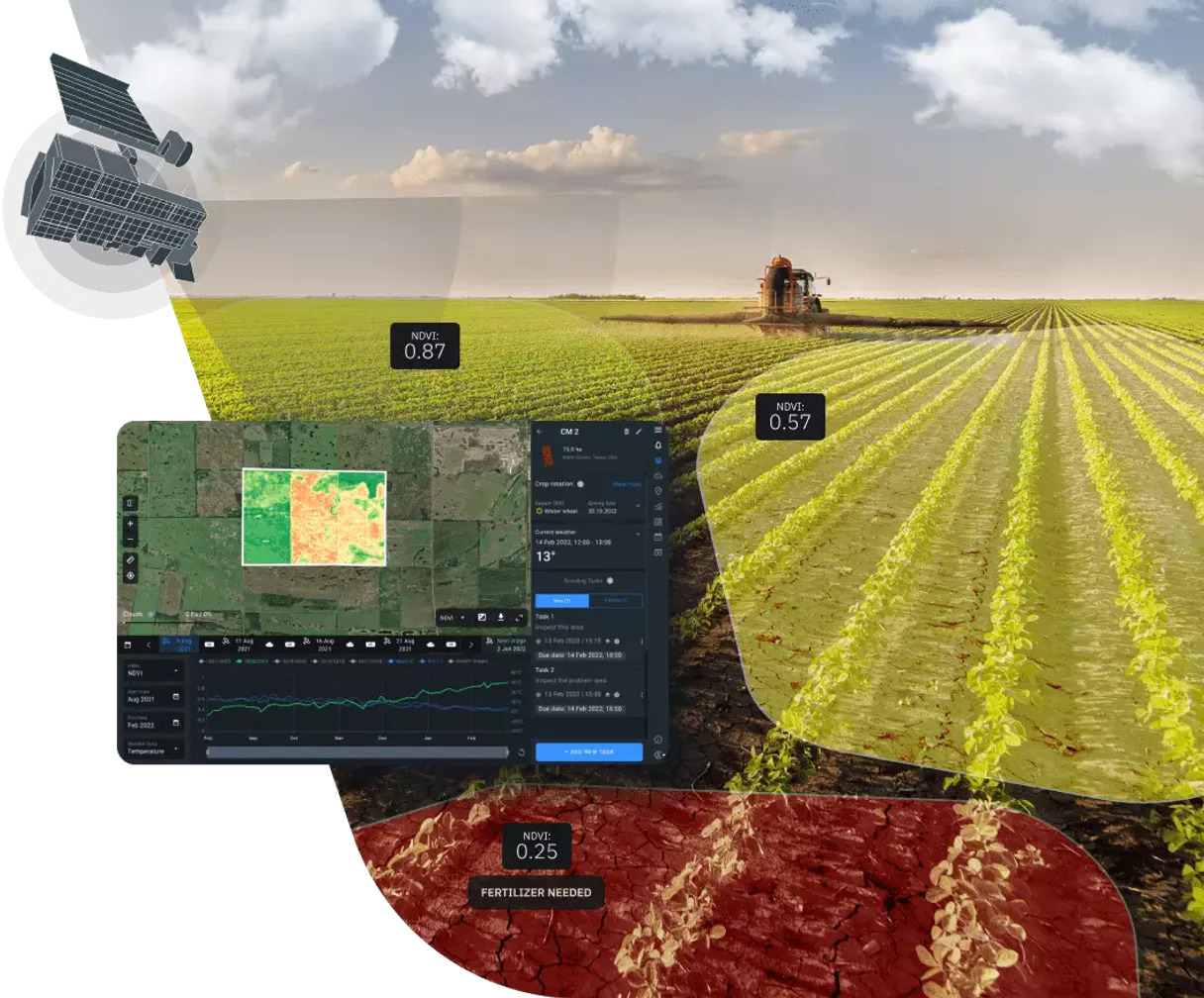
What is the EOSDA Agriculture Satellite Data MCP Server?
Empower your AI agent with cutting-edge remote sensing capabilities via the EOSDA Agriculture MCP server. This integration provides instant access to high-resolution satellite data from Sentinel and Landsat missions, specifically processed for precision farming. Your agent can search for imagery across global datasets, calculate vegetation indices like NDVI, EVI, and MSAVI, and monitor soil moisture trends over time. Whether you are optimizing fertilizer application, auditing crop health, or monitoring land use, your agent acts as a dedicated agronomist and remote sensing specialist through natural conversation.
What you can do
- Satellite Imagery Search — Search Sentinel-2, Landsat 8/9, and MODIS datasets by date and area of interest.
- Vegetation Indices — Trigger processing tasks for NDVI (health), EVI (biomass), and other critical indices.
- Health Monitoring — Retrieve processed results to identify areas of stress or high productivity in fields.
- Dataset Intelligence — Access technical specs for available satellites including resolution and revisit times.
- AOI Analysis — Input GeoJSON areas of interest to get localized intelligence for specific farms or regions.
How it works
- Subscribe to this server
- Enter your EOSDA API Key (from EOS Data Analytics dashboard)
- Start managing your precision agriculture data from Claude, Cursor, or any MCP-compatible client
Who is this for?
- Agronomists & Farm Managers — monitor field performance and crop health without manual site visits.
- Ag-Tech Developers — integrate remote sensing data into custom farming applications.
- Sustainability Officers — track land use changes and vegetation trends over large geographic areas.
- Researchers — access historical and near real-time satellite data for agricultural studies.
Built-in capabilities (6)
) for a specific area of interest. Returns a task ID that can be used with get_task_result to retrieve results. Use get_available_indices to see all available index types. Create a vegetation index calculation task (NDVI, EVI, etc.)
Use these dataset IDs for search_dataset and create_vegetation_task. Get list of available satellite datasets
Use these index types with create_vegetation_task. Get list of available vegetation indices
Returns the processed vegetation index data, download URLs and status. Get the result of a vegetation index task
) within a date range and optional area of interest. Returns scene IDs, dates, cloud cover percentages and download URLs. Use get_available_datasets to see all dataset options. Search satellite imagery for a specific dataset
g. Sentinel-2 and Landsat 8 together). Returns scenes from all requested datasets within the date range and area of interest. Search satellite imagery across multiple datasets
Why Pydantic AI?
Pydantic AI validates every EOSDA Agriculture Satellite Data tool response against typed schemas, catching data inconsistencies at build time. Connect 6 tools through Vinkius and switch between OpenAI, Anthropic, or Gemini without changing your integration code. full type safety, structured output guarantees, and dependency injection for testable agents.
- —
Full type safety: every MCP tool response is validated against Pydantic models, catching data inconsistencies before they reach your application
- —
Model-agnostic architecture. switch between OpenAI, Anthropic, or Gemini without changing your EOSDA Agriculture Satellite Data integration code
- —
Structured output guarantee: Pydantic AI ensures tool results conform to defined schemas, eliminating runtime type errors
- —
Dependency injection system cleanly separates your EOSDA Agriculture Satellite Data connection logic from agent behavior for testable, maintainable code
EOSDA Agriculture Satellite Data in Pydantic AI
Why run EOSDA Agriculture Satellite Data with Vinkius?
The EOSDA Agriculture Satellite Data connection runs on our fully managed, secure cloud infrastructure. We handle the hosting, maintenance, and security so you don't have to deal with servers or code. All 6 tools are ready to work instantly without any complex setup.
You stay in complete control of your data. Your AI only accesses the information you approve, keeping your sensitive passwords and private details completely safe. Plus, with automatic optimizations, your AI works faster and more efficiently.
* Every connection is hosted and maintained by Vinkius. We handle the security, updates, and infrastructure so you don't have to write code or manage servers. See our infrastructure
Over 4,000 integrations ready for AI agents
Explore a vast library of pre-built integrations, optimized and ready to deploy.
Connect securely in under 30 seconds
Generate tokens to authenticate and link external services in a single step.
Complete visibility into every agent action
Audit live requests, latency, success rates, and active security compliance policies.
Optimize spending and track token ROI
Analyze real-time token consumption and cost metrics detailed by connection.


Explore our live AI Agents Analytics dashboard to see it all working
This dashboard is included when you connect EOSDA Agriculture Satellite Data using Vinkius. You will never be left in the dark about what your AI agents are doing with your tools.
EOSDA Agriculture Satellite Data and 4,000+ other AI tools. No hosting, no code, ready to use.
Professionals who connect EOSDA Agriculture Satellite Data to Pydantic AI through Vinkius don't need to write code, manage servers, or worry about security. Everything is pre-configured, secure, and runs automatically in the background.
Raw MCP | Vinkius | |
|---|---|---|
| Ready-to-use MCPs | Find and configure each manually | 4,000+ MCPs ready to use |
| Connection Setup | Manual coding & server setup | 1-click instant connection |
| Server Hosting | You host it yourself (needs 24/7 uptime) | 100% hosted & managed by Vinkius |
| Security & Privacy | Stored in plaintext config files | Bank-grade encrypted vault |
| Activity Visibility | Blind execution (no logs or tracking) | Live dashboard with real-time logs |
| Cost Control | Runaway AI token spend risk | Automatic budget limits |
| Revoking Access | Must delete files or code to stop | 1-click disconnect button |
How Vinkius secures
EOSDA Agriculture Satellite Data for Pydantic AI
Every request between Pydantic AI and EOSDA Agriculture Satellite Data is protected by our secure gateway. We automatically keep your sensitive data private, prevent unauthorized access, and let you disconnect instantly at any time.
Frequently asked questions
What satellites are covered by this integration?
The server provides access to Sentinel-2 (high resolution), Sentinel-1 (radar), Landsat 8 and 9 (historical and medium res), and MODIS (high temporal resolution).
How do I calculate the NDVI for a specific field?
Use the create_vegetation_task tool. You need to provide the index_type as 'NDVI', the dataset_id (e.g., 'sentinel2'), and the aoi (Area of Interest) coordinates in GeoJSON format.
Is the area of interest (AOI) required for searches?
For general searches, it is optional but highly recommended to narrow down results. For index calculation tasks (create_vegetation_task), the AOI is mandatory to define the target area.
How does Pydantic AI discover MCP tools?
Create an MCPServerHTTP instance with the server URL. Pydantic AI connects, discovers all tools, and generates typed Python interfaces automatically.
Does Pydantic AI validate MCP tool responses?
Yes. When you define result types as Pydantic models, every tool response is validated against the schema. Invalid data raises a clear error instead of silently corrupting your pipeline.
Can I switch LLM providers without changing MCP code?
Absolutely. Pydantic AI abstracts the model layer. your EOSDA Agriculture Satellite Data MCP integration works identically with OpenAI, Anthropic, Google, or any supported provider.
MCPServerHTTP not found
Update: pip install --upgrade pydantic-ai
Explore More MCP Servers
View all →
Import.io (Web Data Extraction)
10 toolsExtract structured data from any website via Import.io — run extractors, manage bulk crawls, and monitor API usage.

Harvard Art Museums Alternative
35 toolsExplore the Harvard Art Museums' vast collection — search over 250,000 objects, research artists, and browse exhibitions directly via AI.
Cometly
8 toolsEnable your AI agent to track conversions, retrieve attribution data, and monitor campaigns via the Cometly API.
Open-Meteo Climate & Ensemble
3 toolsProject the future of our planet: IPCC climate simulations to 2100, multi-model ensemble forecasts, and long-term temperature trends — the data backbone for ESG and climate policy AI.